


Project information
- Category: Responsive SaaS Web Application
- Client: Infrastructure Reservation
- Project date: 25 October, 2018
- Project URL: NA
Case Study at a Glance
Product: Infrastructure Reservation
Type: Map based SaaS Platform
Users: Communication Providers & Network Planners
Problem
Infrastructure discovery and reservation is fragmented, non-visual, and error-prone, slowing planning decisions.
Solution
A map-first reservation platform that unifies spatial discovery, availability visibility, and structured request flows.
My Role
End-to-end UX Designer owning research framing, journeys, IA, interaction design, and accessibility.
Impact
- Faster infrastructure discovery
- Reduced cognitive load
- Clearer, more confident reservation decisions
Existing solutions make these answers hard to obtain, increasing planning time, errors, and operational risk.
Infrastructure Reservation
Infrastructure Reservation is a responsive, map-based SaaS application for communication providers to discover and reserve shared infrastructure across the UK. The platform enables location-based search, clear visibility of available and reserved assets, and structured reservation workflows. By combining spatial discovery with compliant request flows, it supports faster and more confident infrastructure planning decisions.
The product brings together:
- Spatial discovery through an interactive map
- Real‑time visibility of infrastructure availability
- Structured reservation workflows with mandatory data capture
The goal is to support faster, clearer, and more reliable infrastructure planning decisions.
1. Project
8 months | Group (Agile)
- End to End UX/Product Designer
- Problem framing and design objectives
- Information architecture and interaction design
- Map‑based UI patterns and responsive layouts
- Accessibility and enterprise usability considerations
My Role
- Figma
- Adobe Illustrator
Software
- Web
Platform
This case study focuses on how service thinking informed key design decisions—not just the final UI.
2. Project Overview
Background
Communication providers rely on shared physical infrastructure—such as ducts, poles, and access nodes—to plan and deploy networks. While this infrastructure is geographically distributed and highly regulated, the tools used to discover and reserve it are often fragmented, non‑visual, and difficult to interpret.
The Challenge
Users need to answer three critical questions quickly:
- What infrastructure exists at a specific location?
- What is available versus already reserved?
- How can I request access with confidence and compliance?
Existing solutions make these answers hard to obtain, increasing planning time, errors, and operational risk.
3. Design Goals
- Enable location‑first infrastructure discovery
- Make available status immediately understandable
- Reduce cognitive load in complex, data‑heavy views
- Prevent late‑stage errors during reservation
- Design a system that scales with additional asset types
4. End‑to‑End User Journey
Home → Reserve New Infrastructure → Search Location → View Infrastructure → Select Assets → Submit Reservation
At a high level, the journey supports:
- Entering the system with a clear intent
- Discovering infrastructure visually by location
- Comparing availability and constraints
- Selecting appropriate assets
- Submitting a structured, compliant request
Each step progressively reveals information to avoid overwhelming the user.

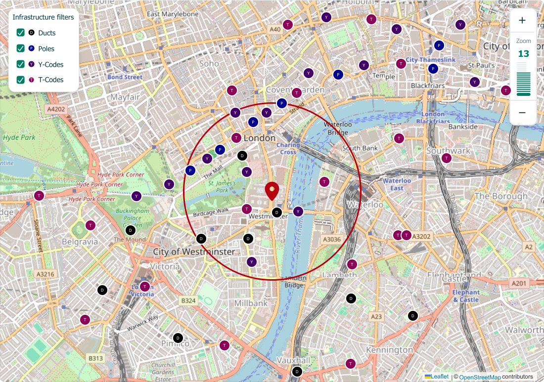
5. Infrastructure Types Supported
The platform supports four primary infrastructure categories:
- T-Codes: Termination or access points
- Y-Codes: Junction or branching nodes
- Ducts: Underground cable pathways
- Poles Overhead infrastructure assets
Each category has:
- Distinct visual representation
- Specific metadata and constraints
- Clear availability states

6. Information Architecture
Navigation Strategy
- Task‑oriented rather than feature‑driven
- Reservation flow prioritized over secondary actions
- Map positioned as the primary workspace
Structural Decisions
- Search and discovery before filtering
- Details revealed through contextual side panels
- Persistent access to selected assets and summaries
This structure supports focus while handling complex data.
7. Map‑Based Discovery Experience
Why a Map‑First Approach?
Infrastructure decisions are inherently spatial. Users reason in terms of where, not just what.
Key Design Considerations
- Interactive map as the central canvas
- Distinct icons for each infrastructure type
- Color‑coded availability states
- Clustering at lower zoom levels
- Clear hover, focus, and selection feedback
Availability is communicated visually before users engage with detailed data.
Different search options available


Search field along with recent search results (has last 5 results)

8. Availability & Status Visibility
Availability states are critical to user trust:
- Available: Clearly selectable
- Partially Reserved: Conditional or limited access
- Unavailable: Reserved or restricted
- Out of Scope: Not eligible for reservation
Status is communicated through a combination of color, iconography, and text to avoid reliance on color alone.


9. Asset Comparison & Selection
To support confident decision‑making:
- Selected assets remain visually highlighted
- A real‑time summary panel reflects current choices
- Conflicts or constraints surface immediately
- Users can revise selections without losing context
This reduces drop‑off and prevents surprises later in the flow.
Infrastructures before selection
Infrastructures after selection

Individual infrastructures details


10. Reservation Form Design
Key Challenges
- Mandatory regulatory fields
- High cost of incorrect submissions
- Context switching between map and form
Design solutions
- Progressive disclosure of form sections
- Pre‑filled context from selected assets
- Inline validation and guidance
- Clear distinction between required and optional inputs
The form supports accuracy without feeling heavy or punitive.


11. Key Design Trade‑Offs
- Visual density vs. clarity on the map
- Speed of submission vs. validation rigor
- Flexibility for users vs. system constraints
Design decisions consistently prioritized clarity, trust, and error prevention over raw speed.
12. Outcomes & Learnings
Outcomes
- Clearer discovery and comparison of infrastructure assets
- Reduced cognitive load in complex decision flows
- Scalable foundation for future infrastructure types
Learnings
- Map‑based systems require restraint as much as richness
- Visibility of status builds confidence faster than added features
- User centric design thinking prevents UI‑only solutions
13. Reflection
Infrastructure Reservation demonstrates how complex, regulated workflows can be made approachable through strong service design. By aligning spatial discovery, availability clarity, and structured reservation flows, the product supports confident decision-making in a high-stakes operational environment.
This project reflects my approach to designing systems that balance usability, scalability, and real-world constraints.
14. Other Screens
Landing page

Individual infrastructure details

Track Orders
Search option in Track Orders

Individual order details

Contact
Location:
Nizampet, Hyderabad, 500090
Email:
vardhan298@gmail.com
Call:
+91-9966936100